


Google Maps to the rescue: the AlertCops Success Story

2019 – SPAIN
THE ORGANISATION
The Sub-directorate General for Security Information and Communication Systems is dependent on the Ministry of the Interior and, more specifically, on the Secretary of State for Security. It is responsible for coordinating, designing, developing and implementing technological services and solutions together with the State Law Enforcement Forces and Agencies for the said forces and for the Spanish Ministry of the Interior.
THE CHALLENGE
The mission of the Law Enforcement Agencies is to guarantee the protection of citizen’s rights. However, society is changing: the way in which individuals interact with each other, with their environment and, therefore, with the police is no longer the same.
Digital transformation is no longer a business term exclusively. It affects every citizen at individual and personal levels.
Within this context, the need has arisen to design an application that adapts to the citizens of today, using their media to offer an effective and modern solution that adapts to the actual situation of society in the 21st century.
The result is, AlertCops, the Police and Civil Guard App.
THE SOLUTION
AlertCops is a service designed by the Spanish Ministry of the Interior to respond to the challenges of digital transformation regarding how citizens interact with Law Enforcement Agencies. In this sense, AlertCops meets all expectations: it has a simple and intuitive interface designed to provide direct contact with the police.
This solution makes use of Google Maps services, which play a key role in the system’s effectiveness.
THE RESULTS
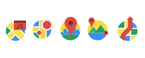
AlertCops is the perfect example of how the combination of Google Maps APIs can make a difference by helping to create a product, based on geolocation services, that meets the needs of its users.
Each of the APIs used by AlertCops contributes to each of the functions it offers:
-
ALERT MANAGEMENT
Every time a citizen triggers an alert through the application, the law enforcement forces receive the coordinates of the transmitting device at their Operations Centre, which allows them to position it on a map.
1. Display in the Operative Center
JavaScript API -allows the map to be displayed. Thanks to this API, we can view any result obtained through the Google Maps APIs that we want to implement.
Geocoding API – allows the geo-positioning of the device from which the alert was transmitted.
Geocoding is the process that transforms addresses (such as, “Torre Picasso, AZCA, Plaza de Carlos Trias Bertran, 1, 28020 Madrid, Spain”) into geographic coordinates (such as latitude 40.4505067 and longitude -3.6930797222222225) that serve to place markers or determine a position on the map.
2. Use of a chat to send the POI (Point of Interest)
Places API – offers:
- places search → uses the power of mobile technology to provide contextual information about the place where the user is located.
- search anywhere → searches and retrieves information about points of interest to provide users with their location.
- autocomplete → provides a query prediction service for text-based geographic searches.
3. Details of the alerts – Reverse geocoding
Geocoding API – Reverse Geocoding – provides the location of the device transmitting the alert even when the information provided via the device is based on coordinates and not on an exact address.
Reverse geocoding is the process of converting geographical coordinates into normal language addresses. The reverse geocoding service provided by Google Maps’ Geocoding API also makes it possible to find an address based on a particular place ID.
4. Display nearby Mobile Assets
If the presence of the Police is required, the Operations Centre will be able to view the officers nearest the place where they are needed.
Distance Matrix API – provides information on the distance and duration of a journey from multiple destinations to a given point (place of the emergency) taking traffic into account.
5. Route
Once the position of the nearest assets (officers) is known, the optimal route to the site of the emergency is generated.
Directions API – among other functions, it calculates travel time based on past and present traffic conditions.
-
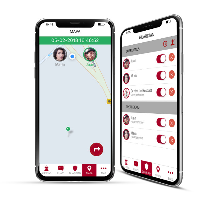
GUARDIAN
By means of the Guardian function, the AlertCops application allows the position of a user (protected person) to be referred to a third party, which can be another SIMASC-registered user that has the AlertCops application installed on their mobile device (private guardian) or a public entity responsible for citizen security (public guardian).
1. Map display on a mobile device and at the Guardian Center
The latest positions of the “protected person” will be displayed as well as the route travelled.
Geocoding API – geocoding and reverse geocoding for the location of the ‘protected person’.
Road API (Snap to Roads) – view of the positions of the “protected person” and routes between the location points.
The Google Maps Road API supports up to 100 GPS points collected on a route and displays a set of similar data with the points adjusted to the most probable routes travelled. You can also request that the points be inserted, which will result in a path that will follow the geometry of the route.
-
GEO ALERT
AlertCops can issue alerts to devices that have the App installed and that are within an area of interest. This system seeks to obtain the collaboration of citizens in the case, for example, of missing persons, as well as the possibility of notifying users of a hazard.
1. Creation a POI and an alert
The use of geofencing to create geolocated areas to send PUSH notifications to devices within that area.
Geocoding API (Geofencing) – allows the geolocation of an area by joining points created based on coordinates.
AlertCops takes full advantage of the technology that Google Maps offers to provide a modern and innovative service to ensure the safety of citizens.
Download the application here.
